Body
Image
The SESI Collaborative: A multi-state, multi-site project integrating GIS into high school instruction
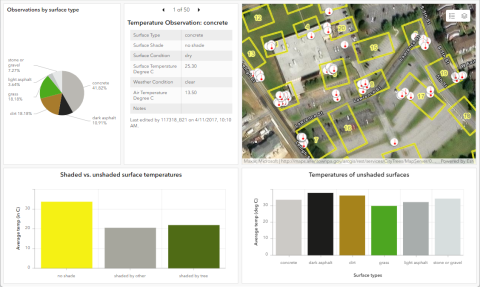
Three universities (Lehigh, Texas Christian, and Washington State University Tri-Cities) are collaborating with teachers at nine high schools to integrate GIS into core curricular content areas (Environmental Science, Biology, Chemistry, Physics, Geography, and more; including special education settings) and specialized classes (Robotics, Forensics, and so on). Our work with teachers spans technical instruction (learning about GIS), curriculum development (co-designing materials for the classroom), and pedagogical modeling. All of the tools we are using with teachers are cloud-based, so our collaboration can take place through a mix of online, face-to-face, and in-class interactions. The curriculum design principles are centered around localized geospatial inquiry into socio-environmental science issues (for example: investigating the urban heat island effect both on school campus and in the local community). Teacher outcomes include enhancement of geospatial TPACK and the patterns of their learning and implementation. Student outcomes include geospatial thinking and reasoning, interest in STEM-related college and career paths. Our project started in the first wave of the pandemic, and we were successful in adapting our work to a purely online context. Our teacher development model has been effective across a variety of contexts, as each of the three universities has a different collection of strengths and is working with its own distinct group of teachers.
Pillar 1: Innovative Use of Technologies in Learning and Teaching
GIS is an innovative, interdisciplinary technology that spans many STEM fields, including both hard sciences and social sciences. The geospatial tools we use include ArcGIS Online, Field Maps and Survey123 for data collection, and Dashboards, StoryMaps, and Hub sites for sharing.
Pillar 2: Partnerships for Career and Workforce Preparation.
Geospatial tools are needed in both STEM research and application, not to mention a wide variety of business, government, and commercial settings. Students in our participating teachers' classrooms are using professional-grade GIS and related tools while learning their curriculum-specified content and exploring STEM- and geospatially-connected college and career paths.
Pillar 3: Strategies for Equity in STEM Education
Our project connects with students from many traditionally underrepresented groups and settings. At the school level, we have rural, urban, and alternative high schools; at the classroom level, we have both general ed and special education classes. Additionally, the geospatial tools we are using are currently free for K12 educational settings. We budgeted for mobile technologies at each school to allow students to participate in data collection regardless of whether or not they owned a smartphone.
Discipline(s)
Other
Target Gradespan(s)
High school (9-12)
Target Participant(s)
Educators
Project Setting(s)
Formal Education
Category
Scaling, Expanding, and Iterating Innovations (SEI)