Body
Resources included in these libraries were submitted by ITEST projects or STELAR and are relevant to the work of the NSF ITEST Program. PDFs and/or URLs to the original resource are included in the resource description whenever possible. In some cases, full text publications are located behind publishers’ paywalls and a fee or membership to the third party site may be required for access. Permission for use must be requested through the publisher or author listed in each entry.
71 - 80 of 1031
NSF 22-585 ITEST Solicitation Webinar
VideoNSF Program Officers present the ITEST Program Solicitation (NSF 22-585) ahead of the August 9, 2024, proposal submission deadline. This webinar details necessary considerations to meet the ITEST goals and pillars, the review criteria that panelists look for, and key elements for research and
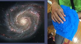
Textured Tactile 3D Prints of Astronomical Data for the Career Exploration Lab and Other Applications
Curricular MaterialsImage

Astronomy has been a fascinating subject for the public for centuries and can stimulate deep questions not only on our own origin but subtly the richness of science and mathematics. It also is a science that is associated with engineering and technology to probe the universe.Typically, astronomical data is translated into visual representations for analysis and general public communication. Unfortunately, this practice is problematic for individuals with blindness or visual impairment (B/VI). In response, we transformed astronomical research data and models into textured 3D prints for tactile
A Lesson in Geospatial Inquiry
PublicationGeospatial Inquiry is an educational framework that offers students an opportunity to engage with, and become curious about, geospatial data for a defined purpose. The authors define Geospatial Inquiry as: "Asking and answering a question through the analysis and communication of data that is linked to a geographic location on, above, or near Earth." (Rubino-Hare et al. 2017). Since Geospatial Inquiry is designed to evoke curiosity and engagement, students have multiple opportunities to seek information and explore ideas on how they see the world they live in. Geospatial Inquiry uses
Scaling professional development: Integrity of implementation as a measurement approach.
PublicationProfessional learning about an innovative teaching method is a demonstrated way to improve teacher practices, and ultimately impact student learning. One way to scale up professional learning is a facilitator development model, in which professional learning and development (PLD) designers prepare facilitators to understand the innovation and they in turn, teach teachers. To understand the effectiveness of this model, identifying how facilitators implement the model with teachers is critical. As such, the Power of Data (POD) team scaled-up effective PLD by providing Facilitation Academies to
Teacher enactment of the Geospatial Inquiry cycle in classrooms Teacher enactment of the Geospatial Inquiry cycle in classrooms following scaled up professional learning and development following scaled up professional learning and development
PublicationThe current study examined the effects of a nationally scaled up Professional Learning and Development (PLD) model on teachers’ classroom implementation of the Geospatial Inquiry instructional framework. Geospatial Inquiry is defined as: asking and answering a research question through the analysis and communication of data that is linked to a geographic location on, above, or near Earth. These data are often represented visually via maps and explored with geospatial technologies. It also examined the relationships between Geospatial Inquiry Teacher Workshop (GITW) implementation and teacher
The impact of Geospatial Inquiry lessons on student interest in science and technology careers
PublicationAdvances in online geospatial technologies (GST) have expanded access to K-12 classrooms which has implications for the support teachers require to effectively integrate GSTs to promote learning. Previous studies have shown the impact of GST-integrated lessons on student engagement, spatial thinking skills, and/or content knowledge; however, most of these studies have been small in scope and scale and frequently focus on the affordances of the technology, without addressing the context of the implementation and student characteristics for whom GST is most impactful. We attempt to address some
STEM Dreams in Motion - Episode 3
VideoThis series of videos highlights contemporary stories of refugees who are considered role models for their tenacity and accomplishments. Each story sheds light on journeys to becoming a STEM professional in the United States. Episode 3 features STEM college students from Syria and Iraq who all
STEM Dreams in Motion - Episode 2
VideoThis series of videos highlights contemporary stories of refugees who are considered role models for their tenacity and accomplishments. Each story sheds light on journeys to becoming a STEM professional in the United States. Episode 2 features Ralph Ngaboyimana. Ralph's family arrived in the United
STEM Dreams in Motion - Episode 1
VideoThis series of videos highlights contemporary stories of refugees who are considered role models for their tenacity and accomplishments. Each story sheds light on journeys to becoming a STEM professional in the United States. Episode 1 features Dr. Tshijik Kabash, an immigrant from the Democratic
Course Videos
VideoWatch the videos below to learn more about STELAR's Developing an ITEST Proposal online course.